
General scores for accessibility and inequality measures in urban areas
Our new paper, written in collaboration with Dr Indaco Biazzo from Polytechnic University of Turin, is now published. We rank public transport accessibility of the biggest cities around the world by looking at city cohesion, average velocity and city sociality.
All over the world, the acceleration of urban growth has led to enhanced urban interactions. Policy-makers and public institutions continuously face challenges related to finding new efficient solutions to transportation problems while ensuring equitable access to resources. In this context, the scientific community can play a crucial role in finding out suitable engines for assessing the present and generate new scenarios.
Our paper on General scores for accessibility and inequality measures in urban areas gives a scientific contribution in this field by providing general methods to evaluate accessibility in cities based on public transportation data. These general metrics allow for a quantitative between-city and within-city comparison. We have defined accessibility as the capacity of cities to enable people to move efficiently by guaranteeing equity and equal access to personal and professional opportunities.
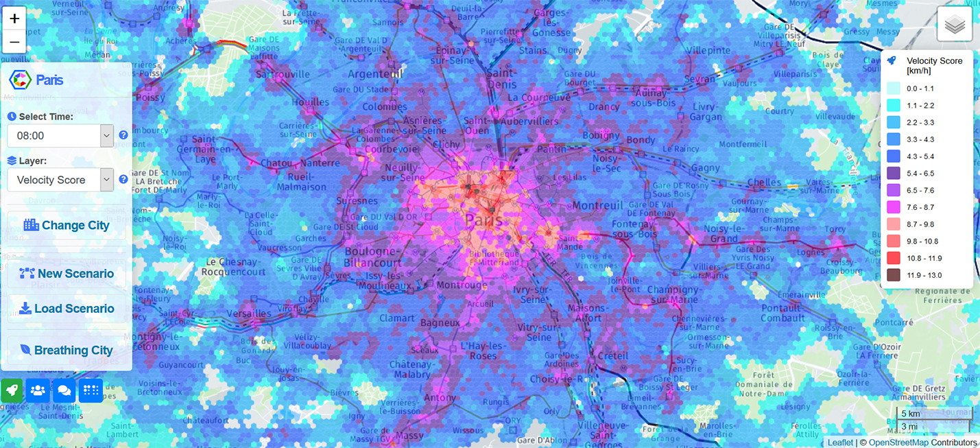
We argue that one way of measuring transportation accessibility is to look at three main urban transportation features: city cohesion, average velocity and city sociality. We have defined city cohesion as a fraction that represents the portion of a population which can be reached when taking a trip into a given city. A velocity score is defined as a function of the average traveling times to get from one place to another. Finally, a sociality score is defined as the average number of possible encounters in a typical day using public transport.
We have followed a common approach in accessibility studies and focused on traveling times between geographical areas. The relevant mathematical notion here is that of isochronic maps, i.e., maps showing isochronic contour lines. We have used isochrones to measure the performance of transport systems in terms of their ability to connect places and people in urban systems. Based on this measure, we have ranked the cities according to their overall accessibility.
Our results show that there are significant inequalities in the distribution of these measures across the population and that such disparities are unexpectedly similar across different urban environments. Previous studies have shown that the quantification of inequalities in the accessibility is a valuable tool to assess economic and social inequalities at an extra-urban scale. Therefore, the use of new tools for planning and simulate new scenarios can be of the utmost importance to project more inclusive and sustainable societies.
Explore our accessibility maps and design new scenarios on Citychrone++
Read the article here
Authors: Indaco Biazzo (Polytechnic University of Turin), Bernardo Monechi (Sony CSL Paris), Vittorio Loreto (Sony CSL Paris)

Maps of the velocity score and the sociality score for six different cities: Paris, New York, Madrid, Montreal, Sidney and Boston. The great variability of the colours indicates a strong dissimilarity of performances of the public transport across cities.